by Howard Eskildsen
“There is no scenery in the world that can beat it. Not that I’ve seen the rest of the world. I don’t need to; I’ve been to Princess Louisa Inlet.” Log of A Landlubber, by Erle Stanley Gardner.
A clear, calm fall day greeted four intrepid travelers as they prepared to cruise to Princess Louisa Inlet in British Columbia in September 1995. It was over 145 nautical miles from Anacortes, Washington where we chartered Bliss, a 32-foot Bayliner. My brother Bernie and his wife Nanci joined Fairy and me for the trip. We had cruised together on a chartered boat before and were eager to set out to this fabled inlet.
Curt, who oversaw the charters, commented that we had an “aggressive” float plan and offered some suggestions and precautions. This would be our first crossing of the Gulf of Georgia; a 20 mile stretch of open water that was prone to rough conditions and had a torpedo range in the middle of it. The most useful advice was to watch the smoke from the lumber mill in Nanaimo. If it arced gracefully into the sky, there would be no problem. It blew horizontally away from the stack, stay in port!
We discussed other details such as timing of the crossing of tidal rapids at Dodd Narrows and Malibu, as well as contingency plans in the event of bad weather. With due precaution and optimism, we cast off into the calm seas and blue skies of early autumn.
Anacortes passed to port as the bow pointed towards Thatcher Pass on the other side of Rosario Strait. Halfway to Thatcher Pass we crossed the area where the Chatham, one of Captain George Vancouver’s boats lost her stream anchor over 200 years ago. We hoped for better luck on our trip.
We traveled past Orcas Landing to Pole Pass, a narrow passage between Orcas and Crane Islands. Its name came from Indians using a net tied between a pole and trees on the other side to catch flying birds. We rounded Steep Point on Orcas Island and cruised north past Stuart Island to Canadian Waters. At Bedwell Harbour on South Pender Island we cleared customs. This was new territory for us and there was a growing sense of adventure as we turned towards Ganges where we would spend the night.
Ganges lay in the direction of the sun on the north end of Saltspring Island. Occasional swells and ripples played with the reflection of the sun over the harbor as we passed the Chain Islands. Several float planes came and went adding to the mystic of the setting.
The stores had closed and the sun was setting as we tied up to the dock. What we were able to see of Ganges left us wishing that we could spend more time there to explore, shop and dine, but we had to cover 110 nautical miles the next day if we were to make Princess Louisa Inlet.
The next morning, we were by Active Pass when the sun rose over Mount Baker. We were five miles from Ganges by that time, motoring through the protected waters of the Gulf Islands. We had to make Dodd Narrows by nine AM to get through at slack water. This would allow us to cross the Gulf of Georgia before the wind and waves came up. After a fuel stop at Pender Harbour there should be time to make the Malibu Rapids slack water. Over 100 nautical miles were still ahead of us, and at 11 knots, that is a very long distance.
One by one, the rest of the party joined me on the bridge. By Porlier Pass, the whole crew was topside. We could see Dodd Narrows, a tiny slit in the land ahead of us and someone remarked, “We’re going through there?!?”
We maneuvered out of the way of an approaching tug with a barge and entered the narrows. As small as the pass had seemed from a distance, there was plenty of room and the current was dead calm. Around the corner the pulp and lumber mill smokestack sent up a plume of smoke arcing gently downwind. It was the sentinel that let us know it was safe to cross the Gulf of Georgia.
We passed Nanaimo and turned east toward Entrance Island. A close eye was kept on the wind and the waves as twenty miles of open water lay ahead of us. Leaving Entrance Island Lighthouse to starboard, we continued our course for another mile before turning north to cross the strait. This would leave us well outside of the torpedo training range! By the Halibut Banks buoy we turned west northwest and went by Merry Island Lighthouse and on to Welcome Pass.
Between Welcome Pass and Pender Harbour we passed Smuggler’s Cove and Secret Cove with their well protected and hidden anchorages. Smuggler’s Cove is said to have been a hiding place for Larry “Pig Iron” Kelly who smuggled Chinese from Canada to the U.S. His nickname came from rumors that he tied his “cargo” to a large chunk of pig iron before setting out for the states. If there was danger of being caught by U.S. Customs, the pig iron was to be thrown overboard, carrying the Chinese to a fate too terrible to imagine.
At the entrance of Pender Harbour, we met the Eviva, a 165 foot yacht, which we later learned was owned by the former CEO of Bayliner. Its port of registry was in the Cayman Islands in the Caribbean! The skipper came out of the pilot house to give a friendly wave as we passed. On the deck behind him rested a helicopter. We could not help but marvel at the places they must have been and the sights they have surely seen.
After fueling at Pender Harbour, a critical decision had to be made. We were about four hours away from Malibu Rapids, the narrow entrance to Princess Louisa. Slack water there would be in four hours and twenty minutes. If we were to arrive late, the current would turn to ebb and pent up waters in the inlet would come tumbling out of the rapids, making safe passage impossible. Return to Pender Harbour would also be impossible as night would be upon us an hour later. The only option would be to attempt a difficult anchorage at the end of Princess Royal Reach in Deserted Bay. If the winds were to kick up as they are known to do in the reach, it could have meant a sleepless night at best.
We continued on, confident that we could make the rapids with 20‑30 minutes to spare. From Pender Harbour we turned right and entered the Agamenon Channel, the beginning of the fjords of the mainland. The waters were in mountainous territory with peaks and glaciers visible through the channel ahead. Next came the junction with Jervis Inlet and the opening of the Sechelt Inlet. The scenery was breathtaking and we were still 20 miles from Princess Louisa.
We traveled north up the Jervis Inlet to Vancouver Bay with Mount Churchill towering 6400 feet above it. In her book, The Curve of Time, M. Wylie Blanchet describes how she and her children in the boat Caprice stopped there and went ashore in the 1920’s. The children played along the shore while she fished the stream flowing into the bay. When she returned the children pointed out the stranger dressed in black standing upright, perhaps a clergyman, who had been watching them. As she looked, the “clergyman” was coming towards them on all four feet! They beat a hasty retreat to the boat while the bear ate the freshly caught fish.
At Vancouver Bay the passage turned left for a few miles and then made a long gradual turn to the right into Princess Royal Reach on the other side of Mount Churchill. To our delight, the reach was behaving herself and the reputed winds were absent. Eight miles ahead lay Deserted Bay. We were right on schedule and could put aside worries about spending the night there.
Deserted Bay had once been the site of the Sechelt Indian village known as Tsoh-nye. It was named by nineteenth century fishermen who came across the site and noticed that there were no signs of life even though many canoes were present. The whole village, except for one infant girl had died of small pox. She was rescued and survived.
At Deserted Bay, the fjord we were following took a sharp left turn into what is known as the Queen’s Reach. As we rounded the point, we could see Malibu at the opening of Princess Louisa a few miles ahead.
The entrance to Malibu Rapids was as quiet as an empty bath tub. Even so, it was a narrow winding passage with reefs and boulders on either side and required careful navigation. It was a relief to see the depth sounder showing deep water again.
Ahead was the deep gorge of Princess Louisa. The eastern walls of the fjord were ablaze with the late afternoon sun. The water was already in the shade. A few cascading falls were on either side. In the wet season there would be many more. Past Macdonald Island and around a bend to the left, the end of the inlet, Chatterbox Falls and Princess Louisa Marine Park came into view.
Princess Louisa Provincial Marine Park was once property of James F. “Mac” Macdonald. He first saw it in 1919 and purchased it in 1927. He made all visitors welcome, once stating, “This beautiful, peaceful haven should never belong to one individual… I have felt that I was only the custodian of the property for Nature and it has been my duty to extend every courtesy.” In 1953 he turned the property over to the Princess Louisa International Society in a perpetual trust so it could remain as nature had made it.
We had built up great expectations, but could never have imagined this sight. Golden rays from the setting sun reflected off peaks and glaciers 7000 feet above the narrow valley at the end of the inlet. The left side of the valley had a vertical rock wall over 2000 feet high that started near the water’s edge. Through out the canyon at the end of the inlet, ribbons of water tumbled down from the mountain peaks finally joining to plunge 120 feet over Chatterbox falls into the sea water below.
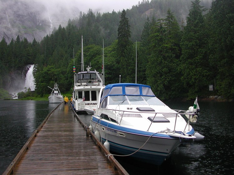
Only four other boats shared the dock at the marine park leaving plenty of space for Bliss and her crew. Near the shore a river otter darted through the shadows. We hiked to the base of the falls in the fading evening light, thankful for Mac’s generosity.
It is named Chatterbox from its ever present sound carrying over the water like a distant conversation. Mrs. Blanchet describes, “That waterfall can laugh and talk, sing and lull you to sleep. But it can also moan and sob, fill you with awful apprehensions of you don’t know what…” In the wet season, boulders can be heard crashing over the falls.
Dinner was served as the twilight turned to darkness. Afterward, Fairy and Nanci shared The Curve of Time, while Bernie and I went outside. The brilliance of the stars between the canyon walls with the Milky Way overhead was as spectacular as the first view of the inlet had been. Soon the whole crew was on the dock watching the stars and seeing an occasional meteor.
“Look at the water!” someone exclaimed. It was twinkling, not with reflected starlight, but with a light of its own and was nearly as bright as the stars. Occasionally the glowing plankton would swirl, tracing the wake of a passing fish. Reluctantly we settled into our berths for the night.
The next day was full of exploration, trying to see as much as possible in the one full day that we had in the inlet. We visited the falls again, and then headed up to the trapper’s cabin. It was an old cabin nearly 2000 feet up the canyon wall over a two mile “trail” that had been described as “strenuous”. Indeed! Two hours later we saw the crumbling cabin nestled in trees at the base of a cliff. We were greeted by trail weary hikers who exclaimed, “You’re the first people we’ve seen in three weeks!” They were happy to see us, for they knew their destination was near.
By the cabin was a small waterfall that must be quite a torrent in the wet season. It danced down to a pool by the trail and then disappeared into a chasm below parting the dense forest. Through the chasm we could gaze the full length of the inlet.
Back down the trail, we made a few wrong turns, but after retracing our steps found the path again. Occasionally we would stop to wonder how (and why) we’d actually climbed up this or that section of the trail. Finally the remains of the old log skid appeared and we were back at the dock.
After lunch, we explored the local area in the dinghy. Across the bay on the other side of Chatterbox Falls, was trapper rock, where the author of The Curve of Time and her children had anchored their boat during their many visits. The shoreline on that side was a jumble of massive boulders shed from the cliffs looming half a mile overhead. It is easy to see why she had an uneasy night after one of the children asked if the rock they were tied to had fallen off that cliff!
In the meantime, some boats left, new ones took their place, and several float planes flew in and out. Along with the planes went the hikers we had met earlier in the day. One of them had a very important date with “the nearest pub”. A helicopter resembling the one we had seen on the Eviva flew by perilously close to the cliffs and then disappeared behind the waterfall. Later it was seen crossing the ridge above the trapper’s cabin.
By late afternoon Bernie and I got around to putting on the wet suits and dive gear to see the underworld. With the turbulence of the falls mixing the fresh and salt waters, the visibility was not as good as hoped. Any disturbance would give the water a foggy appearance and blur the view. After a short time we hauled out of the water and put up the gear.
Bernie had panty hose on to make removal of the dive suit easier. I had forgotten to bring some, but finally managed to wriggle free of the suit. He was content to rinse the salt off the gear while still in wet swim trunks and panty hose, but I had to get some dry clothes on before cleaning up the gear. I forgot one detail.
The dive gear was hanging up to dry when the lady ranger came by asking if we belonged to items left by the visitor’s register. She was obviously distracted by Bernie’s hairy legs showing through the wet panty hose and by the white tee shirt hanging out the fly of my unzipped blue shorts! Two other passers by also cast startled glances over their shoulders.
After we finished dressing, we watched the day fade to night from the bow of the boat with the falls chattering in the background. We were thoroughly exhausted, but battled fatigue for one last glimpse of the night’s light show before turning in.
Sunday dawned with the reluctant realization that is was time to start the return home. The scenery was too grand, however, for us to feel let down. By Macdonald Island, a mink swam across the fjord. We had seen several the day before, but this was the first that had been in the water. Malibu Rapids was still running an ebb current as we approached, so we stopped to wait for the slack.
On the northeast side of the rapids is a large resort complex built in the 1940’s by a wealthy American. This was later “converted” into a Christian youth camp operated by Young Life Association. One of its notable visitors was John Wayne who passed through several times in his converted minesweeper, the Wild Goose. Both the camp and the Wild Goose had brass cannons that they would fire back and forth in mock battles as they passed by the camp much to the delight of all parties involved.
About half an hour before slack water another boat our size went through the passage and we felt is was safe to do the same. There was still a noticeable current, but the overfall had disappeared. While the passage was not difficult, it was a relief to be through and into the Queen’s Reach.
We retraced our route back to Pender Harbour without incident and moored at Garden Bay “Hotel”. It is a restaurant and pub with dock space. The only disappointment was the absence of showers. It did have shore power, and it was nice not to have to worry about conserving the batteries. To that point the sky had been totally clear, but clouds began to form as the high pressure system moved east and a storm front approached. The breeze with the clouds brought apprehension about the next day’s crossing of the gulf.
The next morning was cool and cloudy. The mountain tops were no longer visible, but we could see clear across the Gulf of Georgia. The wind was southwesterly and waves reported 1‑2 feet and expected to decrease through the day. The decision was made to go and the boat headed towards Welcome Pass and into the gulf. It took two hours to get across and was a bit bouncy, but no water entered the boat, and no gear nor breakfasts left the boat during the crossing.
As we approached Nanaimo there was a sense of relief that we had reached our goal and had crossed the last major hurdle of the trip. However, I silently wished to be back at Princess Louisa. The ladies had no such regrets, for ahead was an afternoon of shopping!
The boat was fueled and then moored to a spot on “J” dock reserved for Miss Jenny. (No, the skipper’s name was not Forrest Gump.) The wharfinger told us that Miss Jenny was away fishing on the west side of Vancouver Island and would not be needing the space for a while.
During a leisurely lunch at a water front restaurant the waitress provided the ladies with tips and directions to good shopping locations in town. Bernie and I obediently followed their lead for the rest of the day. We took pride in pointing out what good sports we were.
Tuesday morning we rode an ebbing current through Dodd Narrows and headed to Porlier Pass. Anchorage was made in Lighthouse Bay while Bernie got his diving gear on in preparation for slack water in the pass. I was not comfortable leaving the boat unattended in this narrow anchorage even with two anchors out, so Nanci and I stayed aboard while Bernie and Fairy dinghied around the point to the dive site. The water was slack and when the current began to flood they would drift toward the boat.
Their return was quite a sight, with Fairy in the dinghy and Bernie in the water. The grin in his face and the giggle in his voice as he described the experience let us know that it had been worth the effort for all involved.
On the point at the entrance of the bay was a light house with the keeper and some children waving. They seemed somewhat disappointed that we had not come ashore to visit. I later found out that the light house has been automated and we will not get another chance to visit them.
After lunch at Montague Harbour we set out for Roche Harbor in the U.S. of A. Along the route we slowed by Turn Point on Stewart Island hoping to spot some whales. They never appeared, but some porpoises did come by to play in our wake. We were also paid a visit by a bald eagle that dived to the water in front of our boat, talons ready. Like us, he came up empty handed (taloned?) and continued on his way.
After clearing customs, we spent the night at Roach Harbor. Their evening colors ceremony seemed a fitting end to the trip. We played one last round of “turkey foot” and turned in.
We departed for Anacortes under gray rainy skies with wind from an approaching storm threatening to kick up some waves. The easiest route back to the marina was through the protection of the islands, but we wanted one more chance at spotting a whale. We passed through Mosquito Pass to the southwest edge of San Juan Island and on to Lime Kiln Lighthouse and the open waters of the Strait of San Juan de Fuca.
No whales appeared and the seas were getting frisky so we ducked in through Cattle Pass to the protection of the islands. Two hours later we rounded Cap Sante Point and on to Anacortes Marina. The wind had risen to 20 knots from the south and kicked up the roughest chop that we encountered on the whole trip. It took a little planning and caution to avoid running against the pilings at the entrance of the marina. We learned later that several other charters had come in a day early to avoid the deteriorating weather. What a bunch of “landlubbers”.
Reluctantly, we put away the boat that had been our home for the last seven days. It had taken us farther through more difficult challenges than on any other trip as we pushed the learning curve a bit more. The adventure had not ended, however. Once you’ve been on these waters, you can never really leave.
